The first Russian startup dedicated to comprehensive risk assessment of losses in forest areas
Predictive analysis
and monitoring of factors leading to forest damage
and monitoring of factors leading to forest damage

Predictive analysis
and monitoring of factors leading to forest damage
and monitoring of factors leading to forest damage

Predictive analysis and monitoring of factors leading to forest damage

The analytical tool you need to protect your forest assets!
Our proposal
We can provide you with a report, a marked map with a probabilistic assessment of the occurrence of destructive events in each individual area of your logging site and in its vicinity. Timely identification of risks, and most importantly their ranking will allow you to focus on specific areas of the territory, to assess the investment attractiveness of logging areas for leasing, taking into account completely new information.
Our mission
Maximization of your income from multipurpose
Forest management, as a result of the selection and implementation of the optimal scenario of forestry activities. Creation of a solution effective both from the point of view of income from forest management and ecological sustainability, preservation of biodiversity, natural capital of Russia.
Forest management, as a result of the selection and implementation of the optimal scenario of forestry activities. Creation of a solution effective both from the point of view of income from forest management and ecological sustainability, preservation of biodiversity, natural capital of Russia.
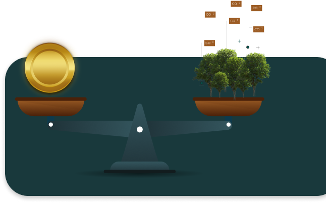
Keeping your carbon units as an exchange-traded asset. Expected price of carbon units (the equivalent of 1 ton of CO2) - 1000 rubles.

Our mission
Maximization of your income from multipurpose
Forest management, as a result of the selection and implementation of the optimal scenario of forestry activities. Creation of a solution effective both from the point of view of income from forest management and ecological sustainability, preservation of biodiversity, natural capital of Russia.
Forest management, as a result of the selection and implementation of the optimal scenario of forestry activities. Creation of a solution effective both from the point of view of income from forest management and ecological sustainability, preservation of biodiversity, natural capital of Russia.
Preserving critical terrestrial ecosystems for future generations, ensuring sustainable forest management. Over the past 30 years, 420 million hectares of forest have been lost (more than the territory of India)! This affects the lives of billions of people who depend on this type of resource.

Our mission
Maximization of your income from multipurpose
Forest management, as a result of the selection and implementation of the optimal scenario of forestry activities. Creation of a solution effective both from the point of view of income from forest management and ecological sustainability, preservation of biodiversity, natural capital of Russia.
Forest management, as a result of the selection and implementation of the optimal scenario of forestry activities. Creation of a solution effective both from the point of view of income from forest management and ecological sustainability, preservation of biodiversity, natural capital of Russia.
Today there are about 1 million species of animals and plants in danger of extinction, some species numbering only tens of individuals. Forests are home to over 80 percent of terrestrial animal, plant and#nbspinsect species.

Our mission
Maximization of your income from multipurpose
Forest management, as a result of the selection and implementation of the optimal scenario of forestry activities. Creation of a solution effective both from the point of view of income from forest management and ecological sustainability, preservation of biodiversity, natural capital of Russia.
Forest management, as a result of the selection and implementation of the optimal scenario of forestry activities. Creation of a solution effective both from the point of view of income from forest management and ecological sustainability, preservation of biodiversity, natural capital of Russia.
Protecting against the effects of climate change, scrubbing carbon from the air and keeping it in the wood and soil (carbon dioxide helps heat up the planet). It is forests that absorb up to 30 percent of all emissions from the use of fossil fuels and industry. Forests are the main fighters against desertification, the protectors of land fertility.
Advantages

Accuracy - 89%
High accuracy predictive risk
3 weeks
Quickly obtaining analytical report
Cost vs. compared to alternatives < 4 times
Solution availability
Reducing the cost of dealing with the aftermath
Our partners


OUR TECHNOLOGIES


receiving AND DATA PROCESSING
Images from space satellites
Receiving data from six satellites allows increasing the resolution of images up to 10 m per pixel, taking into account 19 different spectral layers, as well as minimizing the risk of random errors or outliers in the data when combining images.

Modis
Sentinel-1


Landsat 8


Sentinel-3


Sentinel-1
Landsat 9
OUR TECHNOLOGIES

Images from space satellites
Receiving data from six satellites allows increasing the resolution of images up to 10 m per pixel, taking into account 19 different spectral layers, as well as minimizing the risk of random errors or outliers in the data when combining images.
Modis
Sentinel-1
Landsat 8
Sentinel-3
Sentinel-1
Landsat 9
OUR TECHNOLOGIES
Big relief data

GDEM
Allows you to get a three-dimensional surface relief, determine the angle of slope, exposure at each point - take into account the likelihood of wood blemish.
Global digital elevation model
GDEM
Allows you to get a three-dimensional surface relief, determine the angle of slope, exposure at each point - take into account the likelihood of wood blemish.
Global digital elevation model
OUR TECHNOLOGIES
Meteorological data with a forecast for the future

CDO
They allow you to take into account the hourly information about the temperature, humidity, their predicted values, respectively - to assess the risk of drought, fires, damage to trees in general.
Climate data online
CDO
They allow you to take into account the hourly information about the temperature, humidity, their predicted values, respectively - to assess the risk of drought, fires, damage to trees in general.
Climate data online
OUR TECHNOLOGIES
Soil maps

FAO Soils
The system considers 32 referent soil groups according to the WRB system.
Map of the world of soil resources
FAO Soils
The system considers 32 referent soil groups according to the WRB system.
Map of the world of soil resources
OUR TECHNOLOGIES
Cartographic data

OSM
Allows you to get a three-dimensional surface relief, determine the angle of slope, exposure at each point - take into account the likelihood of wood blemish.
Open street map
OSM
Allows you to get a three-dimensional surface relief, determine the angle of slope, exposure at each point - take into account the likelihood of wood blemish.
Open street map
OUR TECHNOLOGIES
Visualization of risk levels
for the next year
for the next year


Technical advantages

An intelligent software system based on a combination of advanced actuarial methods, artificial intelligence and deep learning models, satellite imagery and fundamental forestry knowledge to improve accuracy.

TEAM
The most advanced deep learning modules Keras, TensorFlow, PyTorch, and advanced models for processing Unet satellite images are used, allowing to perform image segmentation and precisely define forest boundaries.
Full automation of data collection.
Our software package operates 24/7, collecting data from satellites, using know-how algorithms to remove noise, cloud cover, and identify periods of abnormal phytomass reduction.
Our software package operates 24/7, collecting data from satellites, using know-how algorithms to remove noise, cloud cover, and identify periods of abnormal phytomass reduction.
Developers - have many years of experience in developing nonlinear models, machine learning and deep learning models in Python, JavaScript, R, C++. Winners of hackathons in machine learning and big data analysis, Olympiads in financial modeling and business analysis, authors of scientific articles.
Working with big data using Dask technology and Hadoop clusters.
- Processing speed of one application (per 100 hectares of forest): from 3 to 10 days.
- Number of spectral layers of space images for analysis: from 6 to 15.
- Number of developed models, in particular, machine learning: from 3 to 8 (based on UNET, Catboost, LinearRegression, XGBOOST, LGBM, H20, KNN).
- Number of exogenous factors taken into account in the models: indices of vegetative density, meteorological, landscape characteristics, other: from 10 to 40.


Get an analysis
of the risks of destructive factors in and around your site can be as follows


You leave a request
You can leave a request using the form on the site, or write to the mail.
Signing the contract
We will fulfill all conditions under the contract, guaranteeing the quality of services.
Delivering results
We form an analytical report with an assessment of the risks of forest destruction in the areas of interest to you.


Сообщение об успешной отправке!
Evaluating risks
